


Quora discussion: How can NASA's HDEV page be improved?
APOD discussion
[May 27] (NadirCam is back.) When cloud formations seem to have a 3D texture, it's a matter of 6miles high max vs 300miles square, or texturing 1" deep on a 4ft square table...
[May 19, 2014] Since the crew change, all bets are off for which cams will display for how long in what order. Mostly aft, with short bursts of gray. The aft field-of-view is a tiny band within the full circle-of-view (see gif below, and Syria pic below that). I've taken to calling the two aft cams "+7" and "+" to distinguish them, based on the shapes of the panels in the upper right. (This appearance may change when supplies or crews dock and undock.)
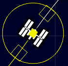
The grid lines on the worldmap take about 8min to cross (93min per orbit /12, 5miles/sec). So if you see pitch black, count the gridlines until sunrise and multiply by 8 to estimate when the picture will reappear. The yellow line is the last orbit, the white is the next. I assume the yellow circle is the ISS field-of-view in all directions, about 1200mi radius, only a tiny strip of which is visible at any time. (When the yellow circle touches the daylight, the sun hits the ISS.) Nadir cam field-of-view is only about 285mi wide = 60sec to cross = 1/7th gridline = ~Iowa
 (It appears the field of view of the forward and aft cams is also quite a narrow band.)
The camera cycle [was supposed to be] not quite 9min (2500 miles, NYC to Las Vegas):
forward view (Hitachi, clear, moving towards us): 2m23s (727mi), nadir view (Toshiba, vertical antenna, clouds moving backwards/ left to right): 1min40s (475mi), aft cam 1 (Sony, panels): 2m28s (703mi), aft cam 2 (Panasonic, panels): 2m07s (603mi) (incl 15sec of grey between each for some crazy reason).
[cite]

Forward and aft cams show disgraceful/wasteful amounts of black sky, within which you can occasionally glimpse the moon or sun.
Seeing the sun rise on an aft cam is kinda cool, because you're looking at pitchblack and then it fades in superquick. The moon is surprisingly tiny, like the letter "o".
Nadir cam is nice for cloud formations, as are the other cams when the sun's angle makes for contrasting shadows (near sunrise or sunset). The color of the land is surprisingly hard to tell from the water, and clouds usually make coastlines undetectable except by deserts, so the middle east is the best area for gauging scales. Always zoom out the Google map a few notches, and make sure you've got cookies enabled at ESA. I also switch to terrain mode, usually.
Twitter status updates (more)
Pix:
Syria with highlighted aftview on ESA maps
the Nile